 |
The navigational triangle is a spherical
triangle formed on the earth's surface by the North Pole (PN
= true North), the observer's estimated position (EP) and the
geographical position of the celestial body (GP). These points
are connected by great circles, two of which are meridians: PN—GP
being the Greenwhich hour angle of the geographical position,
PN—EP being the longitude
for the estimated position.
There are six angles associated with any spherical triangle.
In the navigational triangle, three of these angles are known,
leaving three unknown angles. We need to find two of them to determine
the azimuth and the calculated altitude.
- The calculated altitude
is derived from the angle 90° - Alt. which is shown in the drawing.
When this angle is zero for example, the celestial body will be directly
overhead and the altitude of the
celestial body will be 90° above the horizon.
- Similarly, the azimuth angle
shown is the obverse of the included angle in the triangle which is
actually calculated. It is shown this way because the azimuth
is defined as the bearing of the geographical position as measured
clockwise from true North. If the GP and the EP were swapped
over in this diagram, the azimuth would then be the included angle in
the triangle.
- Using the estimated position and the geographical position
as inputs, sight reduction tables
will give the calculated altitude
and azimuth as outputs.
However, it is fairly easy to derive the calculated altitude and
azimuth on a calculator using the equations:
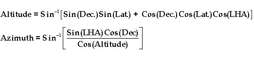 |
Dec |
declination of the celestial body |
| Lat. |
latitude of estimated position |
| LHA |
local hour angle between the two positions |
| |
* Declinations and latitudes south of the equator
are negative; |
The Azimuth derived using these formulae will always be an angle less
than 90°, so a correction will need to made depending on the azimuth quadrant
in which the observed celestial body is located.
If the observed body is in the West and South, add 180° to obtain the
correct Azimuth.
If the observed body is in the West and North, subtract the derived
azimuth from 360° to obtain the correct azimuth.
If the observed body is in the East and South, subtract the derived azimuth
from 180° to obtain the correct Azimuth.
If the observed body is in the East and North, the derived azimuth is
correct.
|
|
